
Setting the Stage for Water Tensions in Africa

Water is a crucial resource - not just to sustain life but entire nations through supporting industry, agriculture, and trade. Accessing water, however, is in reality far from a simple feat, owing to discrepancies in spatial distributions of water resources, man-made demarcations, and societal demand, rendering water an easily politicised and contested resource.

Welcome to my blog, where I explore the theme of water and politics in relation to development. I will examine just how inextricable politics and power relations are to any discussion of water access, focussing specifically on Africa. Few places beyond this continent exemplify the politics of water access more clearly: despite holding abundant freshwater at 9% of global supply (Gaye and Tindimugaya, 2019), a combination of colonial legacies and natural environmental landscape factors mean that Africa is today especially vulnerable to water conflict. In this introductory post, I will explore both these factors in a bit more depth to show how they contribute to the continent's water challenges.

If you look at a map of modern-day Africa, you'll notice a dozen or so stretches of simple straight lines separating some sovereign nations. This was not a coincidence but rather a direct consequence of the Berlin Conference of 1885, where European and western colonial powers met to 'carve up' Africa armed with very limited knowledge of Africa themselves. In many cases, physical features like rivers and river basins were arbitrarily used as the basis of partitions, without consideration of how these natural resources and commons have historically been jointly used and shared, nor the fact that their users are one of the most ethnically diverse globally (Green, 2012; Figure 1). Even following independence in the mid 20th Century, many nations retained these borders and their associated water use agreements, extending and exacerbating issues of water rights and access, and deepening the entanglement between access to water and politics. Today, despite new water use agreements being drawn up, colonial-era agreements are sometimes still being used by countries if and when it favours their water access (Mwilima, 2021; Tekuya, 2020). For example, the Nile River's two upstream riparians - Egypt and Sudan - cited British colonial agreements allocating its water to both states and awarding Egypt veto rights to any Nile River projects, serving as a major source of conflict in the Nile Basin particularly with the construction of the Grand Ethiopian Renaissance Dam, a topic to which I hope to return in later posts.
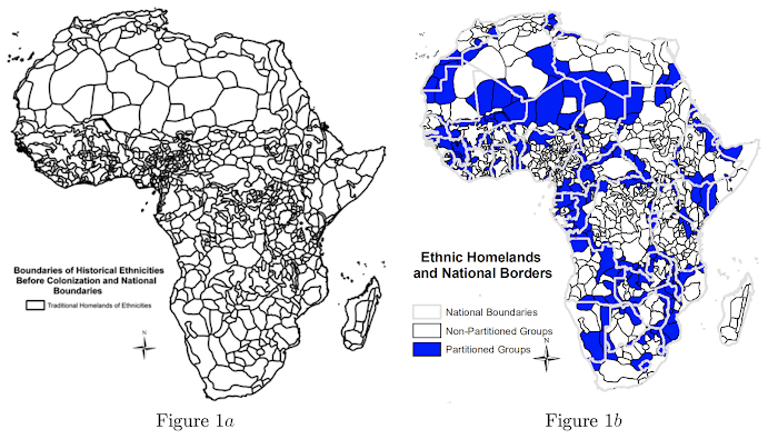
 Figure 1: National borders (Figure 1white lines) of contemporary Africa have little regard for the various ethnic groups and associated natural resources such as water employed by them (Source).
 

On top of this, Africa faces distinct natural environmental conditions and, by extension, spatial-temporal water distribution patterns. The eastern and southern portions of the continent's raised platform-like landscape - which stands at around 1,000m above sea-level - means the potential for developing low-cost irrigation is low, due to the limited presence of low-lying deltas and floodplains (Taylor, 2004). The position of the intertropical convergence zone (ITCZ) also brings drastic seasonal variations in rainfall, with areas at latitudes on either extreme of the ITCZ oscillation (e.g. Lusaka) experiencing a unimodal wet season (i.e. single annual rainy season), while lower latitudes (e.g. Nairobi) receive much more precipitation under a bimodal pattern (i.e. two distinct rainy seasons; Taylor, 2004). Regions towards the coast in southern Africa (e.g. Cape Town) lie beyond the ITCZ oscillation and thus feature a relatively more arid Mediterranean climate, as well as the most variable river discharge in Africa (McMahon et al., 2007). The Orange-Senqu River basin for instance hosts one of the world's largest inter-basin water transfer schemes, diverting water from Lesotho to South African cities far away from blue water reserves such as Johannesburg and Pretoria, though not without invoking tension and conflict in the process (Mirumachi, 2015). We will return to this particular case study soon.

Figure 2: Seasonal changes in the position of the ITCZ (Source).

It's clear that the issue of equitable water access in Africa is not an issue of supply but one of politics and distribution, with spatially and seasonally variable environmental conditions complicated by policies and practices from the colonial era. Together, these factors create the prime conditions for competition and conflict over water resources. Over the coming weeks, I hope to turn to specific examples where politics becomes entangled with water through aspects like interbasin transfers, dam construction, food, and more, focussing mostly on the Orange-Senqu River basin as well as other notable regions.

See you next week!

Comments

  1. Hi Adrian, it was very interesting to read about the links between environmental conditions and how they can complicate the politics of water accessibility. I am looking forward to reading more of your posts!

    ReplyDelete
    Replies
    1. Thanks for reading, hope you find my other posts as insightful and engaging!

      Delete
  2. A nice introductory post about the geophysical and political implications of water but also its relation to historical arrangements. Well written with good engagement with literature, with a defined scope for analysis of water politics.

    ReplyDelete

Post a Comment

Popular posts from this blog

A viable solution to transboundary basin allocation issues? The case of southern Africa

Previously, I introduced the premise of water contestation in Africa continentally, outlining a mismatch in water needs and distribution exacerbated by climatic and political factors. I now wish to delve into a region whose transboundary tensions, conflict, and mediation over water I find particularly interesting: southern Africa and the Orange-Senqu river basin. A large swathe of inland southern Africa is dominated by the previously mentioned kilometre-high plateau and a narrow coastal belt that is especially mountainous towards South Africa - this creates sharp topographic gradients, which have a marked effect on weather systems' movement, orographic precipitation, and hence noticeable rainfall distribution and vegetation gradients across southern Africa (Reason, 2017) . The Orange-Senqu basin lies in the heart of the region, with its main river straddling four countries: it rises from Lesotho's Maluti Mountains and traverses westwards across South Africa, Botswana, and Namib

Managing the Orange-Senqu river basin

Following my post introducing the Orange-Senqu basin and LHWP, you probably wondered what Lesotho and South Africa's bilateral arrangement means for water distribution downstream. After all, discourse surrounding the 'hydropolitics' of transboundary basins typically emphasise asymmetrical effects between upstream and downstream riparians. Also, how has the basin been managed and to what degree of success? Today's post will examine these questions further. Basin management framework The Orange-Senqu river basin has an established record of regional and international agreements in place. Amongst one basin-wide and six bilateral agreements, the 1986 LHWP treaty and 1992 agreement creating the region's Permanent Water Commission in particular established the foundations for joint transboundary water projects, along with institutions overseeing them (Kistin and Ashton, 2008) . As part of the Southern African Development Community (SADC) - an intergovernmental organisatio